Friday, September 25, 2009

Saturday, September 12, 2009


New Light Source
Litroenergy

Very soon, Cyalume sticks (aka glow sticks) will be history. MPK CO. has invented a new kind of light source called Litroenergy that acts somewhat like a glow stick, but lasts more than 12 years without ever needing a recharge. No electricity nor solar exposure required!
“The Litrospheres are not effected by heat or cold, and are 5,000-pound crush resistant. They can be injection molded or added to paint. The fill rate of Litroenergy micro particles in plastic injection molding material or paint is about 20%. The constant light gives off no U.V. rays, and can be designed to emit almost any color of light desired.”
Litroenergy used on a bicycle
Safe, consistent, and eco-friendly. Litroenergy could possibly save billions of dollars for the world.
But smart netizens has dug out Litroenergy’s patent application, and it says the active ingredient used is Tritium. That is the tricky part - United States has a ban on the import of Tritium, probably due to its radioactive nature.
Do you think this product will ever materialize?


Just FYI .............
Friday, September 11, 2009
Head Phone in Future ....
PilletePillete, the new concept of Bluetooth headset is so tiny, it’s almost invisible to the untrained eye when you are wearing it. So you don’t have to worry anymore about looking like Robocop when walking down the street with it, but you have to consider the possibility of people starting to think you’ve lost your marbles and you’re talking to yourself.
The downside is the fact that people have different sized ears and the device might be too small and slip out or to big and not fit. People who often use earphones will tell you I’m right. But once they’ll figure out a way to make the Pillete adjustable, this design will be the future of all headsets.

History of Indian Tricolor

"A flag is a necessity for all nations. Millions have died for it. It is no doubt a kind of idolatry which would be a sin to destroy. For, a flag represents an Ideal The unfurling of the Union Jack evokes in the English breast sentiments whose strength it is difficult to measure. The Stars and Stripes mean a world to the Americans. The Star and the Crescent will call forth the best bravery in Islam."
"It will be necessary for us Indians Muslims, Christians Jews, Parsis, and all others to whom India is their home-to recognize a common flag to live and to die for."
- Mahatma Gandhi
Every free nation of the world has its own flag. It is a symbol of a free country. The National Flag of India was designed by Pingali Venkayyaand and adopted in its present form during the meeting of Constituent Assembly held on the 22 July 1947, a few days before India's independence from the British on 15 August, 1947. It served as the national flag of the Dominion of India between 15 August 1947 and 26 January 1950 and that of the Republic of India thereafter. In India, the term "tricolour" refers to the Indian national flag.
The National flag of India is a horizontal tricolor of deep saffron (kesari) at the top, white in the middle and dark green at the bottom in equal proportion. The ratio of width of the flag to its length is two to three. In the centre of the white band is a navy blue wheel which represents the chakra. Its design is that of the wheel which appears on the abacus of the Sarnath Lion Capital of Ashoka. Its diameter approximates to the width of the white band and it has 24 spokes.
Evolution of the Tricolour
It is really amazing to see the various changes that our National Flag went through since its first inception. It was discovered or recognised during our national struggle for freedom. The evolution of the Indian National Flag sailed through many vicissitudes to arrive at what it is today. In one way it reflects the political developments in the nation. Some of the historical milestones in the evolution of our National Flag involve the following:
Unofficial flag of India
in 1906
 The first national flag in India is said to have been hoisted on August 7, 1906, in the Parsee Bagan Square (Green Park) in Calcutta now Kolkata. The flag was composed of three horizontal strips of red, yellow and green.
The Berlin committee
flag, first raised by
Bhikaiji Cama in 1907
 The first national flag in India is said to have been hoisted on August 7, 1906, in the Parsee Bagan Square (Green Park) in Calcutta now Kolkata. The flag was composed of three horizontal strips of red, yellow and green.
The flag used during the
Home Rule movement
in 1917
 The second flag was hoisted in Paris by Madame Cama and her band of exiled revolutionaries in 1907 (according to some inl9OS). This was very similar to the first flag except that the top strip had only one lotus but seven stars denoting the Saptarishi. This flag was also exhibited at a socialist conference in Berlin.
The flag unofficially
adopted in 1921

The third flag went up in 1917 when our political struggle had taken a definite turn. Dr. Annie Besant and Lokmanya Tilak hoisted it during the Home rule movement. This flag had five red and four green horizontal strips arranged alternately, with seven stars in the saptarishi configuration super-imposed on them. In the left-hand top corner (the pole end) was the Union Jack. There was also a white crescent
and star in one corner.
The flag adopted in 1931.
This flag was also the
battle ensign of the
Indian National Army
 During the session of the All India Congress Committee which met at Bezwada in 1921 (now Vijayawada) an Andhra youth prepared a flag and took it to Gandhiji. It was made up of two colours-red and green-representing the two major communities i.e. Hindus and Muslims. Gandhiji suggested the addition of a white strip to represent the remaining communities of India and the spinning wheel to symbolise progress of the Nation.
The present Tricolour
flag of India
 The year 1931 was a landmark in the history of the flag. A resolution was passed adopting a tricolor flag as our national flag. This flag, the forbear of the present one, was saffron, white and green with Mahatma Gandhi's spinning wheel at the center. It was, however, clearly stated that it bore no communal significance and was to be interpreted thus.
On July 22, 1947, the Constituent Assembly adopted it as Free India National Flag. After the advent of Independence, the colours and their significance remained the same. Only the Dharma Charkha of Emperor Asoka was adopted in place of the spinning wheel as the emblem on the flag. Thus, the tricolour flag of the Congress Party eventually became the tricolour flag of Independent India.
Colours of the Flag:
In the national flag of India the top band is of Saffron colour, indicating the strength and courage of the country. The white middle band indicates peace and truth with Dharma Chakra. The last band is green in colour shows the fertility, growth and auspiciousness of the land.
The Chakra:
This Dharma Chakra depicted the "wheel of the law" in the Sarnath Lion Capital made by the 3rd-century BC Mauryan Emperor Ashoka. The chakra intends to show that there is life in movement and death in stagnation.
Flag Code
On 26th January 2002, the Indian flag code was modified and after several years of independence, the citizens of India were finally allowed to hoist the Indian flag over their homes, offices and factories on any day and not just National days as was the case earlier. Now Indians can proudly display the national flag any where and any time, as long as the provisions of the Flag Code are strictly followed to avoid any disrespect to the tricolour. For the sake of convenience, Flag Code of India, 2002, has been divided into three parts. Part I of the Code contains general description of the National Flag. Part II of the Code is devoted to the display of the National Flag by members of public, private organizations, educational institutions, etc. Part III of the Code relates to display of the National Flag by Central and State governments and their organisations and agencies.
There are some rules and regulations upon how to fly the flag, based on the 26 January 2002 legislation. These include the following:
The Do's:
* The National Flag may be hoisted in educational institutions (schools, colleges, sports camps, scout camps, etc.) to inspire respect for the Flag. An oath of allegiance has been included in the flag hoisting in schools.
* A member of public, a private organization or an educational institution may hoist/display the National Flag on all days and occasions, ceremonial or otherwise consistent with the dignity and honour of the National Flag.
* Section 2 of the new code accepts the right of all private citizens to fly the flag on their premises.
The Don'ts
* The flag cannot be used for communal gains, drapery, or clothes. As far as possible, it should be flown from sunrise to sunset, irrespective of the weather.
* The flag cannot be intentionally allowed to touch the ground or the floor or trail in water. It cannot be draped over the hood, top, and sides or back of vehicles, trains, boats or aircraft.
* No other flag or bunting can be placed higher than the flag. Also, no object, including flowers or garlands or emblems can be placed on or above the flag. The tricolour cannot be used as a festoon, rosette or bunting
Reference : Indian Government site
Thursday, September 10, 2009
WINNERS VERSUS LOSERS
¨ The Winner is always part of the answer; The Loser is always part of the problem.
¨ The Winner always has a program; The Loser always has an excuse.
¨ The Winner says, "Let me do it for you"; The Loser says, "That is not my job."
¨ The Winner sees an answer for every problem; The Loser sees a problem for every answer.
¨ The Winner says, "It may be difficult but it is possible"; The Loser says, "It may be possible but it is too difficult."
¨ When a Winner makes a mistake, he says, "I was wrong";
When a Loser makes a mistake, he says, "It wasn't my fault."
¨ A Winner makes commitments; A Loser makes promises.
¨ Winners have dreams; Losers have schemes.
¨ Winners say, "I must do something"; Losers say, "Something must be done."
¨ Winners are a part of the team; Losers are apart from the team.
¨ Winners see the gain; Losers see the pain.
¨ Winners see possibilities; Losers see problems.
¨ Winners believe in win-win; Losers believe for them to win someone has to lose.
Winners see the potential; Losers see the past.
¨ Winners are like a thermostat; Losers are like thermometers.
¨ Winners choose what they say; Losers say what they choose.
¨ Winners use hard arguments but soft words; Losers use soft arguments but hard words.
¨ Winners stand firm on values but compromise on petty things; Losers stand firm on petty things but compromise on values.
¨ Winners follow the philosophy of empathy: "Don't do to others what you would not
want them to do to you";
Losers follow the philosophy, "Do it to others before they do it to you."
¨ Winners make it happen; Losers let it happen.
¨ Winners plan and prepare to win.
The key word is preparation.
Interesting Facts about India
* India never invaded any country in her last 100000 years of history.
* When many cultures were only nomadic forest dwellers over 5000 years ago, Indians established Harappan culture in Sindhu Valley (Indus Valley Civilization)
* The name 'India' is derived from the River Indus, the valleys around which were the home of the early settlers. The Aryan worshippers referred to the river Indus as the Sindhu.
* The Persian invaders converted it into Hindu. The name 'Hindustan' combines Sindhu and Hindu and thus refers to the land of the Hindus.
* Chess was invented in India.
* Algebra, Trigonometry and Calculus are studies, which originated in India.
* The 'Place Value System' and the 'Decimal System' were developed in India in 100 B.C.
* The World's First Granite Temple is the Brihadeswara Temple at Tanjavur, Tamil Nadu. The shikhara of the temple is made from a single 80-tonne piece of granite. This magnificent temple was built in just five years, (between 1004 AD and 1009 AD) during the reign of Rajaraja Chola.
* India is the largest democracy in the world, the 6th largest Country in the world, and one of the most ancient civilizations.
* The game of Snakes & Ladders was created by the 13th century poet saint Gyandev. It was originally called 'Mokshapat'. The ladders in the game represented virtues and the snakes indicated vices. The game was played with cowrie shells and dices. In time, the game underwent several modifications, but its meaning remained the same, i.e. good deeds take people to heaven and evil to a cycle of re-births.
* The world's highest cricket ground is in Chail, Himachal Pradesh. Built in 1893 after leveling a hilltop, this cricket pitch is 2444 meters above sea level.
* India has the largest number of Post Offices in the world.
* The largest employer in the world is the Indian Railways, employing over a million people.
* The world's first university was established in Takshila in 700 BC. More than 10,500 students from all over the world studied more than 60 subjects. The University of Nalanda built in the 4th century was one of the greatest achievements of ancient India in the field of education.
* Ayurveda is the earliest school of medicine known to mankind. The Father of Medicine, Charaka, consolidated Ayurveda 2500 years ago.
* India was one of the richest countries till the time of British rule in the early 17th Century. Christopher Columbus, attracted by India's wealth, had come looking for a sea route to India when he discovered America by mistake.
* The Art of Navigation & Navigating was born in the river Sindh over 6000 years ago. The very word Navigation is derived from the Sanskrit word 'NAVGATIH'. The word navy is also derived from the Sanskrit word 'Nou'.
* Bhaskaracharya rightly calculated the time taken by the earth to orbit the Sun hundreds of years before the astronomer Smart. According to his calculation, the time taken by the Earth to orbit the Sun was 365.258756484 days.
* The value of "pi" was first calculated by the Indian Mathematician Budhayana, and he explained the concept of what is known as the Pythagorean Theorem. He discovered this in the 6th century, long before the European mathematicians.
* Algebra, Trigonometry and Calculus also originated in India.Quadratic Equations were used by Sridharacharya in the 11th century. The largest numbers the Greeks and the Romans used were 106 whereas Hindus used numbers as big as 10*53 (i.e. 10 to the power of 53) with specific names as early as 5000 B.C.during the Vedic period.Even today, the largest used number is Terra: 10*12(10 to the power of 12).
* Until 1896, India was the only source of diamonds in the world
(Source: Gemological Institute of America).
* The Baily Bridge is the highest bridge in the world. It is located in the Ladakh valley between the Dras and Suru rivers in the Himalayan mountains. It was built by the Indian Army in August 1982.
* Sushruta is regarded as the Father of Surgery. Over2600 years ago Sushrata & his team conducted complicated surgeries like cataract, artificial limbs, cesareans, fractures, urinary stones, plastic surgery and brain surgeries.
* Usage of anaesthesia was well known in ancient Indian medicine. Detailed knowledge of anatomy, embryology, digestion, metabolism,physiology, etiology, genetics and immunity is also found in many ancient Indian texts.
* India exports software to 90 countries.
* The four religions born in India - Hinduism, Buddhism, Jainism, and Sikhism, are followed by 25% of the world's population.
* Jainism and Buddhism were founded in India in 600 B.C. and 500 B.C. respectively.
* Islam is India's and the world's second largest religion.
* There are 300,000 active mosques in India, more than in any other country, including the Muslim world.
* The oldest European church and synagogue in India are in the city of Cochin. They were built in 1503 and 1568 respectively.
* Jews and Christians have lived continuously in India since 200 B.C. and 52 A.D. respectively
* The largest religious building in the world is Angkor Wat, a Hindu Temple in Cambodia built at the end of the 11th century.
* The Vishnu Temple in the city of Tirupathi built in the 10th century, is the world's largest religious pilgrimage destination. Larger than either Rome or Mecca, an average of 30,000 visitors donate $6 million (US) to the temple everyday.
* Sikhism originated in the Holy city of Amritsar in Punjab. Famous for housing the Golden Temple, the city was founded in 1577.
* Varanasi, also known as Benaras, was called "the Ancient City" when Lord Buddha visited it in 500 B.C., and is the oldest, continuously inhabited city in the world today.
* India provides safety for more than 300,000 refugees originally from Sri Lanka, Tibet, Bhutan, Afghanistan and Bangladesh, who escaped to flee religious and political persecution.
* His Holiness, the Dalai Lama, the exiled spiritual leader of Tibetan Buddhists, runs his government in exile from Dharmashala in northern India.
* Martial Arts were first created in India, and later spread to Asia by Buddhist missionaries.
* Yoga has its origins in India and has existed for over 5,000 years.
Music Player by Dual
Dual Music Player That Plays Your MP3 Collection & Your CDs -Designer: Yong-Seong Kim
You want to enjoy your audio CDs while traveling but you also have a huge MP3 collection at home that you want to take with you. The ideal solution? DMP, a portable music player that supports CD and MP3 files. Use the MP3 player as you normally would, hang it around your neck, clip it on your jeans or place it in your pocket. Otherwise open both sides and insert your favorite CD and you got yourself a CD player my friend. Now that’s music to my ears.


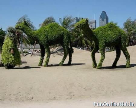
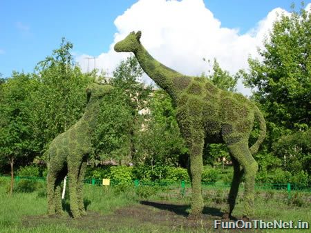
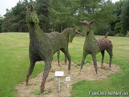
10 Awesome Grass Sculptures
Here are 10 amazing sculptures made only of grass! Quite intricately sculpted, must see sculptures! Includes sculptures from elephants to giraffes to even unicorns!
Cool and creative Formula 1 car grass figure
Cow grass sculpture
This is an amazing elephant grass sculpture.
Giraffe grass sculpture found in Krasnoyarsk, Siberia during summer time.
In the grounds of a country house in Cornwall near the fishing village of Mevagissy the Victorian gardens have been restored to their former glory
Men grass sculpture at Museum Beelden aan Zee in Scheveningen by Wim Quist architects.
The sculpture, In the Garden of Dreams, was made by brother and sister team Sue and Pete Hill.This sculpture was created as a sister to the Mud Maid which can be found at the Lost Gardens of Heligan in Cornwall.
If you have ever visited an art gallery and felt assailed by the "don't touch" signs, then Lucy Strachan's work is for you. Her outdoor sculptures cry out to be touched - or even stroked and hugged, something the artist herself encourages. “Spinning Top” was Lucy's first grass work.
Unicorns United.


10 Most Extreme Places on Earth
Here is a list of the most extreme places on Earth! From the hottest to the coldest place, from the highest to the lowest and many more!
Lut Desert (Iran): hottest place on Earth at 159 °F (71 °C)
There is a big discussion about the hottest spot on Earth. Many believe it is in Al Azizyah, Libya, with a recorded temperature of 136 degrees Fahrenheit (57.8 Celsius), and the second hottest place being in Death Valley, California, USA, where it got up to 134 Fahrenheit in 1913. But according to other sites, a NASA satellite recorded surface temperatures as high as 71 °C (159 °F) in the Lut desert of Iran, supposedly the hottest temperature ever recorded on the surface of Earth. This region, which covers an area of about 480 kilometers, is called Gandom Beriyan (the toasted wheat).
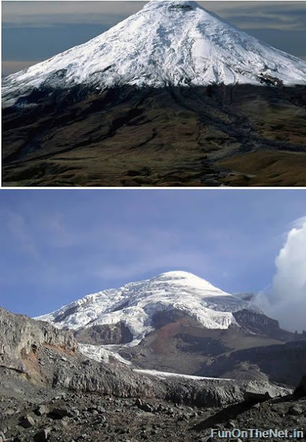
Mt. Chimborazo (Ecuador): highest point above Earht's center at 20,703 feet (6,310 m) above sea level
Almost everyone knows that Mount Everest is the highest mountain in the world. Climbers from everywhere travel to Everest hoping to earn the distinction of climbing the "World's Highest". The peak of Mount Everest is 8,848 meters (29,028 feet) above sea level. This high elevation gives Mount Everest the distinction of being the mountain with the highest altitude.
But not many people know about Mt Chimborazo in Ecuador with an altitude of 6,310 meters (20,703 feet), which is less than Mount Everest; however, Chimborazo has the distinction of being the highest mountain above Earth's center. This is because Earth is not a sphere - it is an oblate spheroid. As an oblate spheroid, Earth is widest at its equator. Chimborazo is just one degree south of Earth's equator and at that location it is 6,384 kilometers from Earth's center or about 2 kilometers farther from Earth's center than Mount Everest.
Ecuadorians find pride in this interesting fact. Nonetheless, Chimborazo cannot compare in difficulty, lack of oxygen, nor in fame, to Mount Everest. (Link | Photo)
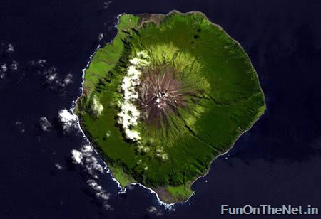
Tristan de Cunha (UK): most remote inhabited archipelago on Earth at 2,000 miles from the nearest continent
The most remote inhabited island group in the world, Tristan de Cunha in the southern Atlantic Ocean, is so tiny its main island has no airstrip. Home to 272 people sharing just 8 surnames, inhabitants suffer from hereditary complaints like asthma and glaucoma. Annexed by the United Kingdom in the 1800s, the island's inhabitants have a British postal code and, while they can order things online, it takes a very long time for their orders to arrive. But then, that's the trade off for having your own island settlement some 2,000 miles from the nearest continent. (Link | Photo)
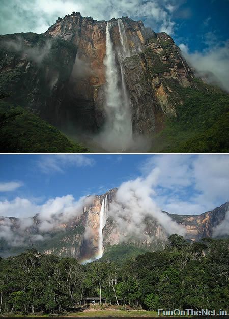
Angels Falls (Venezuela): Earth's highest waterfall with 3230 feet (984 m) in height
Angel Falls (Salto Ángel) in Venezuela is the highest waterfall in the world. The falls are 3230 feet in height with an uninterrupted drop of 2647 feet. Angel Falls are located on a tributary of the Rio Caroni. The falls are formed when the tributary stream falls from the top of Auyantepui (a tepui is a flat-topped structure surrounded by cliffs - similar to a mesa).
Oymyakon (Russia): coldest inhabited place on Earth at −96.2 °F (−71.2 °C)
Oymyakon is a village in Oymyakonsky Ulus of the Sakha Republic, Russia, located along the Indigirka River, 30 kilometers (20 mi) northwest of Tomtor on the Kolyma Highway. The population is 800 people. Oymyakon is known as one of the candidates for the Northern Pole of Cold, because on January 26, 1926, a temperature of −71.2 °C (−96.2 °F) was recorded there. This is the lowest recorded temperature for any permanently inhabited location on Earth. It is also the lowest temperature recorded in the Northern hemisphere.
The lowest temperature ever recorded on Earth was -129 °F in 1983, at the Russian Base Vostok in Antarctica.
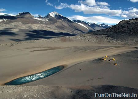
The Dry Valleys (Antarctica): driest place on Earth
One interior region of the Antarctic is known as The Dry Valleys. These valleys have not seen rainfall in over two million years. With the exception of one valley, whose lakes are briefly filled with water by inland flowing rivers during the summer, the Dry Valleys contain no moisture (water, ice, or snow). The reasons why the Dry Valleys exist are the 200 mph Katabatic down winds which evaporate all moisture. The dry valleys are strange: except for a few steep rocks they are the only continental part of Antarctica devoid of ice. Located in the Trans-Antarctic Range, they correspond to a mountain area where evaporation (or rather, sublimation) is more important than snowfall, thus all the ice disappears, leaving dry barren land.
Another driest place is the Atacama Desert in Chile, some parts of which have received absolutely zero precipitation in centuries. Parts of the Atacama Desert may actually exceed the dryness of most of Antarctica, though data from the latter is insufficient to tell.
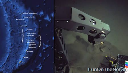
Marianas Trench (Indonesia and Japan): lowest point on Earth at 35,840 feet (10,924 m) below sea level
Challenger Deep in the Mariana Trench (or Marianas Trench) is the deepest point in Earth's oceans. The bottom there is 10,924 meters (35,840 feet) below sea level. If Mount Everest, the highest mountain on Earth, were placed at this location it would be covered by over one mile of water. The only people to have ever explored this trench were Jacques Piccard and Don Walsh. At the bottom they were seven miles down and all around them eight tons of pressure. They observed fish, shrimp and other creatures living on the bottom of the sea floor. (Link | Photo)
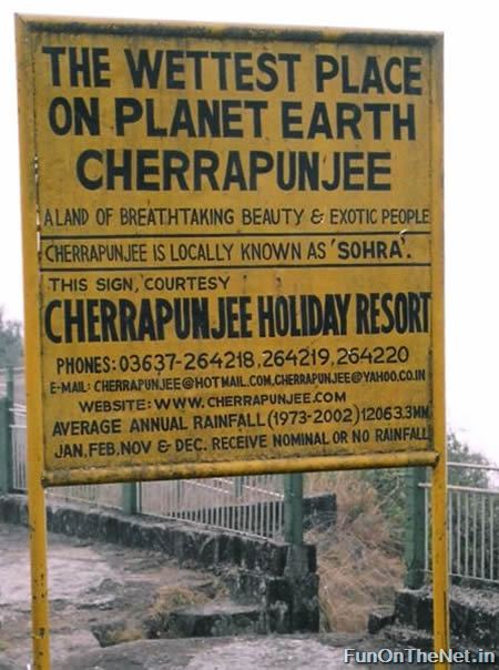
Cherrapunji (India): wettest place on Earth
Cherrapunji, North-Eastern India is thought for many years to be the wettest place in the world. Here 10,820mm rain falls on average in a year. Unlike Colombia where the rain falls throughout the whole year, Cherrapunji gets most of its rain during the 'south-west monsoon', or wet season, between June and August. Cherrapunji does hold the record for the wettest month on record, recording 9,296mm in July 1861. Actually, between 1860 and 1862 Cherrapunji was incredibly wet; between August 1st 1860 and July 31st 1861 (which overlaps parts of 2 wet seasons) 26,467mm rain fell. In the calendar year 1861 22,987mm rain fell, of which 22,454 fell between April and September.
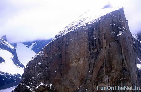
Mount Thor (Canada): Earth's greatest vertical drop
Mount Thor, in Auyuittuq National Park on Baffin Island, Nunavut, Canada, presents a 4,100 foot pure vertical drop. Mt. Thor is Canada's most famous peak, and it's made of pure granite. It's a favorite of thrill seekers and climbers. Mount Thor was first climbed in 1953 by an Arctic Institute of North America team. There have been a few recent rappel expeditions, with one fatality in 2006. (Link)
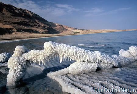
Dead Sea (Jordan): Earth's lowest elevation at 1,385 ft (422 mt) below sea level
The Dead Sea is the lowest elevation on Earth's surface on dry land, its surface and shores are 422 meters (1,385 ft) below sea level. On the border of Jordan and Israel, the road around the Dead Sea also happens to be the lowest road on Earth. Famous for its salinity (over ten times that of the Mediterranean Sea), the Dead Sea is said to be home of the first health retreat. Because of the extreme salt content, no life can survive in the sea, hence the name.

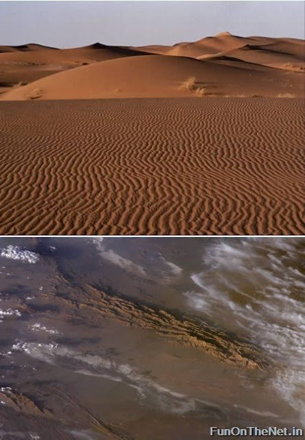

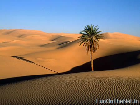
10 Most Captivating Deserts
Here are 10 of the most Captivating and Breathtaking Deserts! From the Sahara, the worlds largest to the Farafra in Egypt and even the Taklamakan, a desert covered with snowfall!
Taklamakan (Central Asia): a desert covered with snowfall
Taklamakan is one of the largest sandy deserts in the world, ranking 15th in size in a ranking of the world's largest non-polar deserts. It covers an area of 270,000 km2 (100,000 sq mi) of the Tarim Basin, 1,000 kilometres (620 mi) long and 400 kilometres (250 mi) wide. It is crossed at its northern and at its southern edges by two branches of the Silk Road as travelers sought to avoid the arid wasteland.
In 2008, China's biggest desert experienced its biggest snowfall and lowest temperature after 11 consecutive days of snow. Snow is rare in the desert that covered 337,600 square kilometers, never before had the whole desert been covered.
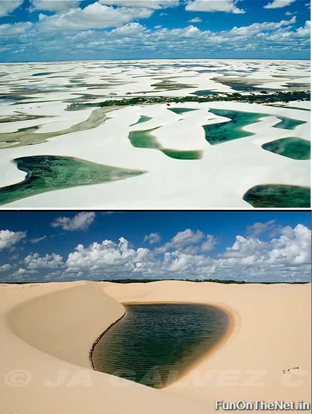
Lençóis Maranhenses (Brazil): a ‘desert' with lagoons
It seems incredible, but in a country that keeps around 30% of the fresh water and shelters the largest rain forest in the world, we can find a “desert”. Located in the State of Maranhão, on the north shore of Brazil, the Lençóis Maranhenses National Park is an area of about 300 square kilometers (155,000 ha) of blinding white dunes and deep blue lagoons, forming one of the most beautiful and unique places in the world. The dunes invade the continent over 50km (31 miles) from the cost, creating a landscape that reminds a white bed sheet, when seen from above.
But you may ask: -Lagoons?? You told me it was a desert… Yes, what defers this region from a desert is the amount of rain that drops over the dunes, creating ponds of crystal clear water on the depression between dunes. Despite its desert-like appearance, Lençóis Maranhenses records an annual rainfall of 1,600mm (i.e. 62.9 inches), 300 times more than in the Sahara. During the period of drought, the lagoons evaporate and become completely dried. After the rainy season, the lagoons are home of many species of fish, turtles and clams. The mystery in this story lies in the fact that when the lagoons fill up, life comes back, as if they had never left the place. One of the hypotheses to explain the phenomenon is that the eggs of the fish and crabs are maintained alive in the sand, exploding when rain comes back.
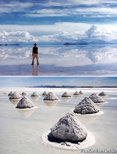
Salar de Uyuni (Bolivia): the world's largest salt desert
The Salar is one of the iconic images of Bolivia, a massive salt desert in the middle of the Altiplano. It is an expansive, virtually flat desert that reflects the sun in such a way as to create a mirror effect with the sky. There are several lakes in the desert with strange colours from the mineral deposits in the region.
Some 40,000 years ago, the area was part of Lake Minchin, a giant prehistoric lake. When the lake dried, it left behind two modern lakes, Poopó Lake and Uru Uru Lake, and two major salt deserts, Salar de Coipasa and the larger Uyuni. Uyuni is roughly 25 times the size of the Bonneville Salt Flats in the United States. It is estimated to contain 10 billion tons of salt, from which less than 25,000 tons is extracted annually.
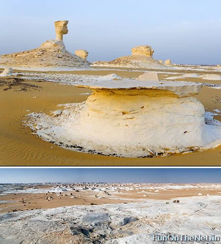
Farafra (Egypt): the white desert
A main geographic attraction of Farafra is its White Desert (known as 'Sahara el Beyda,' with the word 'sahara' meaning a desert). The White Desert of Egypt is located 45 km (30 miles) north of Farafra. The desert has a white, cream color (it is truly white, in clear contrast with the yellow deserts elsewhere) and has massive chalk rock formations that have been created as a result of occasional sandstorms in the area.
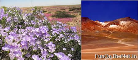
Atacama (Chile): the flourished desert
The Atacama Desert occupies the largest amount of the Chilean territory located north of the 29th parallel. The area located on the coast between Arica and Antofagasta appears in the Guinness Book of World Records as the driest place in the world. Nevertheless, to the south of the Tropic of Capricorn, the desert becomes kinder towards living beings. The coastal mists, "camanchacas", are more abundant south of Antofagasta and bring the humidity necessary for the maintenance of the coastal scenic vegetation. Many plants survive mainly because of the "camanchaca", and the harsh savings of water, in normal dry years, that causes them to delay important functions such as growth, to favor survival and reproduction. (Link)
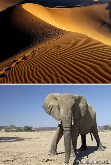
Namib (Namibia): the only desert with elephants
South of Africa lies the Namib desert. which is less vast than the Sahara but just as impressive. It forms part of the Namib-Naukluft National Park with neighbouring Angola. The Sossusvlei sand dunes are the highest in the world, some towering at 300m high and if you are lucky enough, you can stumble across desert elephants-the Namib is the only desert in the world to have elephants. Apparently the oldest desert in the world, myriad species of plants and animals can only be found here. The Namib has fascinated geologists for years but it remains very little understood to this day. Off the coast, strong southerly winds with fogs and strong currents cause sailors to lose their way; the north coast has been named 'Skeleton Coast' due to the amount of shipwrecks found there, some of which can be found as much as 50m inland, as the desert slowly takes over the ocean as it moves westwards.
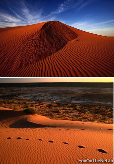
Simpson Desert (Australia): the red sand desert
Australia is home to four large deserts, popularized by Mad Max: Sturt's Stoney Desert, Tanami Desert, the Great Victoria Desert and the Simpson Desert, which is also known as 'The Big Red' due to the presence of dunes of red sand. The Simpson Desert is an erg which contains the world's longest parallel sand dunes. These north-south oriented dunes are static, held in position by vegetation. They vary in height from 3 metres in the west to around 30 metres on the eastern side. The most famous dune, Nappanerica, or, more popularly, Big Red (named by Simpson Desert traveller Dennis Bartell), is 40 metres in height.
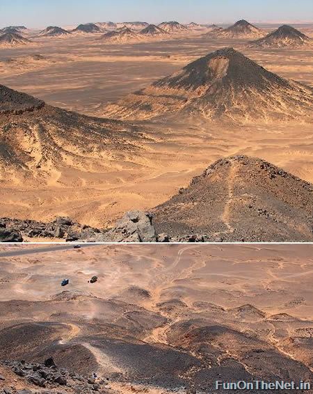
The Black Desert (Egypt): the desert with black stones
Located 100km northeast of the White desert, the Black Desert is a region of volcano-shaped mountains with large quantities of small black stones. The stones lie out across the orange-brown ground, so that it is not quite as black as many people may hope for. Especially after visiting the White Desert, which has formations that are really white, many will imagine a desert as dramatic as this. Climbing one of the many soft peeks, the view from the top is really nice, with similar peeks continuing on into the haze. The Black Desert is uninhabited. (Link)
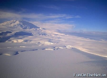
Antarctica: world's driest and wettest desert
Antarctica is a land of extremes. It's not inhabited year round by humans because it's simply too freezing cold. In 1983 scientists recorded extreme cold temperatures as low as -129 Fahrenheit. It's also the wettest place on Earth, but simultaneously the driest. The reason it's the “wettest” is not because of rainfall; since Antarctica is covered by 98% ice, it's technically very wet. However since it's also the aforementioned coldest place in the world, it gets very little precipitation – less than 2 inches a year. Which makes Antarctica a desert. A brutally cold ice desert with a massive trench full of even more…ice. Three for the price of one!
Sahara (North Africa): world's largest desert
The Sahara, with a size of 8.6 million km², is the world's largest desert, covering large parts of North Africa. Around 4 million people live there. Its maximum length is 4,800 km, running from west to east, and up to 1,200 km from north to south. Sahara covers most of Mauritania, Western Sahara, Algeria, Libya, Egypt, Sudan, Chad, Niger and Mali, and touches Morocco and Tunisia.
Sahara is very dry but there is an annual rainfall in most regions, although just a few dozen millimetres.


![Reblog this post [with Zemanta]](https://lh3.googleusercontent.com/blogger_img_proxy/AEn0k_sSVFhJNG2CPRj7niOtjX5YUrOwMIgewQpry7r9ejOSCX963XOGIucT1NqM89sa5LyTeXUPGxYBlvdw7-QxlTK4amVGmUE3-AV76a-m4FypI6goM8xx6qx_UA4JW0ANaViMkH3nbgvAOsXeotlTqJg=s0-d)
Subscribe to:
Comments (Atom)
